News

Weather
Posted: Apr 26, 2024 1:18 PMUpdated: Apr 26, 2024 1:19 PM
Flooding, Severe Risk Increases Through Weekend

Nathan Thompson
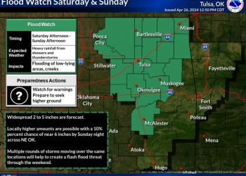
Several rounds of showers and thunderstorms forecast over the weekend have resulted in a flood watch being issued for several counties in Oklahoma, including the counties in our listening area.
The National Weather Service issued the flood watch from 4 p.m. Saturday though 1 p.m. Sunday for excessive rainfall and runoff, which may result in flooding of rivers, creeks, streams and other low-lying, flood-prone areas.
Showers and thunderstorms are expected to develop to the west of the area Saturday afternoon, and increase in coverage and intensity as these storms move into eastern Oklahoma Saturday evening. The storms are expected to continue into the overnight hours. Conditions are favorable during that time for slower moving thunderstorms that train over the same areas.
2 to 4 inch amounts may be common across the watch area with locally higher amounts. Those living in areas prone to flooding should be prepared to take action should flooding develop.
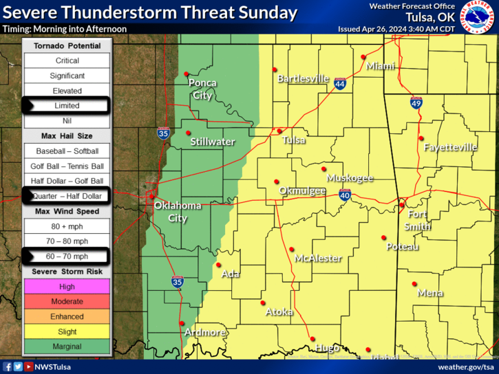
The severe thunderstorm potential will ramp up Friday afternoon and continue into this evening with additional rounds of storms are expected to develop. All modes of severe weather are possible with tornadoes, large hail and damaging winds all possible.
.png)
Additionally, there is an enhanced risk - that's level 3 out of 5 - for severe weather Saturday afternoon and evening. Several rounds of strong to severe storms are possible on Saturday, with the highest severe threat across northeast Oklahoma. Some storms during the afternoon and evening could bring higher-end impacts, including very large hail and tornadoes. Indications are that an organized squall line will sweep east across the region Saturday night into Sunday morning, with damaging winds and a tornado threat as well.
.png)
The severe threat begins to diminish for our Sunday, but there will still be showers and a few storms possible. A round of storms is likely to be ongoing into Sunday morning, with a continued wind and hail threat. Some afternoon redevelopment is possible in the wake of the morning storms, and these storms would be strong to severe with mainly a hail and wind threat.
Be sure to have a battery-operated radio ready as we head through the weekend.
« Back to News