
News

Weather
Posted: Apr 22, 2026 12:34 PMUpdated: Apr 22, 2026 12:34 PM
Severe Weather Possible Beginning Thursday Night, Stormy Weekend Ahead

Nathan Thompson
Several rounds of showers and thunderstorms are expected over northeast Oklahoma and southeast Kansas from Thursday night through the weekend. Some of the storms could be severe.
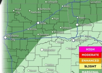
Thunderstorm chances return Thursday, and increase Thursday evening into Friday morning across the area. A Level 1 of 5 severe weather risk is outlooked for northeast Oklahoma, with a Level 2 of 5 risk area possible in northern Chautauqua, Montgomery and Labette counties in Kansas. Large hail and damaging winds are the main severe threats, though a limited tornado threat does exist.


Thunderstorms may be ongoing early Friday morning and expand in coverage and intensity through the day. A Level 2 of 5 risk of severe weather is outlooked Friday southeast of the I-44 corridor while a frontal boundary sets up over the region. Locally heavy rainfall and flooding potential may also develop.

The chances of severe weather continue Saturday and Sunday along the frontal boundary. Large hail and damaging winds are the main hazards each day.


« Back to News