News

Weather
Posted: May 18, 2026 9:47 AMUpdated: May 18, 2026 10:23 AM
Severe Weather Risks Increase Through Early Tuesday Morning

Severe weather risks increase Monday afternoon and through the overnight hours, however, a strong atmospheric cap may hold, limiting the risk to just the overnight hours.
If conditions change to weaken the cap Monday afternoon, isolated strong to severe storms could form ahead of a frontal system. These storms would support very large hail, damaging winds and potentially a tornado or two.

The chance of severe weather will increase Monday night and early Tuesday morning as the frontal boundary approaches. The timing would be after midnight, with higher probabilities from 2 a.m. through 6 a.m. Tuesday. The risks overnight include golf ball-sized hail, 70 mph winds and a limited tornado threat.

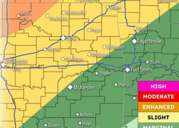
Overall for Monday afternoon through Tuesday morning, a Level 3 of 5 risk area exists from northwest Chautauqua and northwest Osage counties and points to the west. A Level 2 risk area exists for the rest of the listening area.

The severe weather risk area will move southeast of the listening area during the daylight hours Tuesday.
« Back to News